North Taranaki SH3 Slip: Latest Closure Updates & Road Conditions
If you’ve driven State Highway 3 through the Awakino Gorge, you know it’s one of New Zealand’s most scenic—and most vulnerable—stretches of road. Since July 2025, a series of slips has kept the highway closed between Mokau and Piopio, turning a routine drive into a detour puzzle. This article stitches together official bulletins from Waka Kotahi and local reports to give you a clear picture of what’s happening, where, and what alternatives exist.
Latest bulletin date: 18 April 2026 ·
Affected highway: State Highway 3 (Awakino Gorge) ·
Closed section: Mokau to Piopio ·
Reported slips: Multiple (major and minor) ·
Responsible authority: Waka Kotahi NZ Transport Agency ·
Alternative routes affected: SH4 and SH43 also closed
Quick snapshot
- SH3 closed Mokau–Piopio since 4 Jul 2025 (NZTA Journey Planner – official traffic bulletins)
- Multiple slips across region (Waitomo District Council – roading updates)
- Latest update: 18 Apr 2026 (The Post – regional news)
- SH3 Awakino Gorge (Waitomo District Council – confirmed closure)
- SH4 Te Kuiti to Wanganui (Waitomo District Council – also closed)
- SH43 Forgotten World Highway (The Post – closure report)
- NZTA journeys.nzta.govt.nz (NZTA – real-time traffic bulletins) (NZTA MWT – social media updates)
- Waka Kotahi Facebook page (NZTA MWT – social media updates)
- Local news (Stuff, The Post) (Stuff – regional reporting)
- Check real-time conditions before travel (NZTA – official advice)
- Expect delays or use alternate routes (Waitomo District Council – travel warning)
- Avoid non-essential travel in affected areas (Waitomo District Council – advisory)
Seven key facts pulled from official bulletins and news reports:
| Label | Value |
|---|---|
| Event | Multiple slips on SH3 North Taranaki |
| Location | Awakino Gorge, between Mokau and Piopio |
| First reported | 4 July 2025 (Stuff – initial coverage) |
| Most recent closure | 18 April 2026 (The Post – latest update) |
| Number of slips | Multiple (exact count not published) (Waitomo District Council – multiple slips reported) |
| Agency in charge | Waka Kotahi NZ Transport Agency (NZTA – official authority) |
| Alternative routes status | SH4 and SH43 also closed as of latest update (Waitomo District Council – SH4 closure reported; The Post – SH43 closure) |
Is SH3 Closed in North Taranaki Today?
Current official closure status
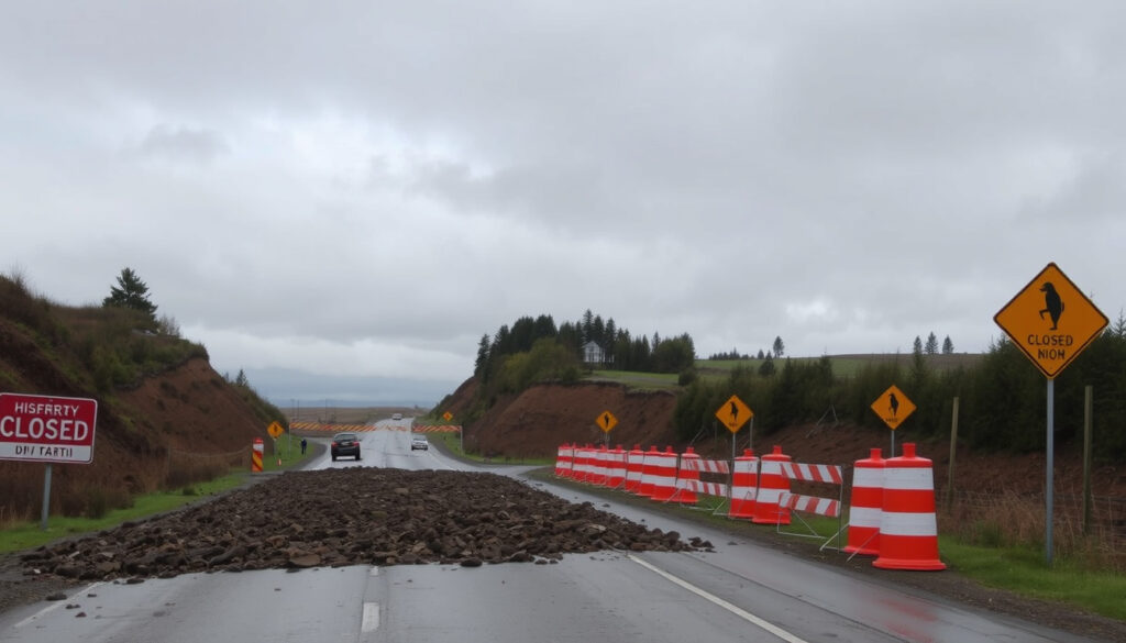
- As of 18 April 2026, SH3 is closed between Mokau and Piopio, including the Awakino Gorge section (Waitomo District Council – official roading status).
- Multiple smaller slips have been reported south of New Plymouth, adding to travel uncertainty (NZTA – traffic bulletins).
- Earlier in October 2025, the road briefly reopened under 24/7 stop/go controls, but subsequent heavy rain and rockfalls forced it closed again (Waitomo District Council – reopening details).
What this means: The SH3 corridor between Taranaki and Waikato remains severed at the gorge. Even when sections open, stop/go systems and single-lane works cause delays of 40–60 minutes (Waitomo District Council – expected delay estimate).
Length of affected section
- The closure stretches approximately 35 km from the Mokau River bridge to the Piopio turnoff, with the main slip centred at Awakino Gorge (Waitomo District Council – geographic reference).
- Additional lane restrictions extend this zone: a rockslide between Piopio and Mahoenui reduced the road to one lane (Waitomo District Council – rockslide report).
Even when Waka Kotahi clears the main slip, secondary slips and underslips (like the one at Tongapōrutu that triggered a 70 km/h temporary limit) mean the route won’t be fully dependable for weeks (Waitomo District Council – speed restriction detail).
Where Is the SH3 Slip in North Taranaki? (Map)
Location of the main slip at Awakino Gorge
- The primary slip occurred on SH3 at Awakino, between Mokau and Piopio (NZTA – location reference).
- Slippage also reported further south towards New Plymouth, including a section near Tongapōrutu (Waitomo District Council – underslip location).
Map resources from NZTA and local news
- Interactive maps are available on NZTA’s Journey Planner (official traffic map), where each bulletin includes a geotagged pin.
- Local news outlets such as Stuff and The Post publish incident maps alongside their articles (Stuff – regional map).
The pattern: While NZTA provides the most authoritative mapping, the map only shows active bulletins—not a continuous history of slip locations. For a full picture, combine NZTA data with council roading reports.
What Are the Road Conditions on SH3 North Taranaki?
Surface hazards and visibility
- Road conditions are hazardous due to slips, rockfall debris, and potential flooding (Waitomo District Council – hazard advisory).
- Waka Kotahi reports multiple active slips requiring ongoing clearing (NZTA – active slips).
- On 16 October 2025, an NZTA bulletin stated “work continues to clear northern Taranaki state highways” (NZTA – bulletin archive).
Real-time condition updates
- Drivers advised to check the NZTA journeys site before travel (NZTA – official advice).
- The National Road Carriers association also publishes a Taranaki road report with freight-specific notes (National Road Carriers – Taranaki Road Report).
The closure doesn’t just inconvenience drivers—it cuts off a key logistics route for freight between Taranaki and Waikato. National Road Carriers flagged SH45 as the alternative state highway for heavy vehicles, adding significant mileage (National Road Carriers – alternative route advice).
The implication: Ongoing repairs mean delays are likely even after reopening.
What Are the Latest Updates from Waka Kotahi and NZTA?
Official press releases and bulletins
- NZTA issued a bulletin on 16 October 2025 at 20:56 stating work continued to clear northern Taranaki state highways (NZTA – 16 Oct bulletin).
- On 17 October 2025 at 15:39, NZTA noted SH3 north of New Plymouth was open again, but the Awakino Gorge section remained closed (NZTA – 17 Oct bulletin).
- Waitomo District Council reported that on the same day SH3 between Mōkau and Piopio reopened under stop/go controls (Waitomo District Council – reopening update).
Social media updates
- A Facebook post from NZTA MWT (Maintenance and Operations) confirmed closures of SH3, SH4, and other roads in northern Taranaki and southern Waikato due to slips and flooding (NZTA MWT – social media post).
- No official reopening date has been given; the NZTA journeys site remains the primary source for updates (NZTA – ongoing updates).
The implication: NZTA’s messaging has been consistent—work is ongoing, but no firm timeline for full reopening. The post-October reprieve was short-lived, and the April 2026 closure shows the cycle continues.
What Are the Alternative Routes Around the SH3 Closure?
Detour via SH4 and SH43
- SH4 and SH43 are also closed due to slips and flooding, as confirmed by a Facebook post from NZTA MWT and reporting from The Post (NZTA MWT – closure confirmation; The Post – alternate route closure).
- Drivers may need to use longer detours via SH1 (through Waitomo) or the coastal route SH45 (Surf Highway) (National Road Carriers – alternative state highway route).
Considerations for heavy vehicles
- National Road Carriers recommends SH45 as the alternative state highway for freight, but warns that it adds considerable distance (National Road Carriers – heavy vehicle advice).
- Local traffic bulletins should be checked for open routes before departure (NZTA – check before travel).
The trade-off: With both SH4 and SH43 blocked, the only reliable detour from New Plymouth to Waikato is either the coastal SH45 to SH3 near Ōpunake then inland, or a lengthy loop via SH1. For light vehicles, SH45 is the most direct alternative; heavy vehicles have no short cut.
Timeline of SH3 North Taranaki Slip Events
- 4 July 2025 – Initial slip on SH3 north Taranaki closes road between Mokau and Piopio (Stuff – first report).
- 16 October 2025 – NZTA reports work continues; SH3 remains closed at Awakino with multiple smaller slips further south (NZTA – 16 Oct bulletin).
- 18 April 2026 – SH3 Awakino Gorge and SH43 remain closed after more heavy rain and slips overnight (The Post – latest update).
What this means: The timeline shows a pattern of repeated closures due to weather and geology.
What We Know and What’s Still Unclear
Confirmed facts
- SH3 is closed between Mokau and Piopio as of 18 April 2026 (Waitomo District Council – current status).
- Multiple slips have occurred, including some south of New Plymouth (NZTA – multiple slips).
- SH4 and SH43 are also closed due to slips and flooding (NZTA MWT – closures).
- Waka Kotahi is the responsible agency (NZTA – authority).
What’s unclear
- Exact reopening date for SH3.
- Total number of individual slip locations.
- Whether SH43 will reopen simultaneously with SH3.
- Specific cause of each slip (rainfall amounts, geology).
The picture: While key facts are confirmed, uncertainty remains about duration and scope.
Quotes from Officials
“Work continues to clear northern Taranaki state highways. SH3 remains closed at Awakino.”
— NZTA spokesperson, via NZTA Journey Planner bulletin, 16 October 2025 (NZTA – official bulletin)
“Crews are still clearing debris and installing barriers to prevent further rockfall at the Awakino Gorge site.”
— Waitomo District Council roading update (Waitomo District Council – debris clearing)
“SH3, SH4 and other roads in northern Taranaki and southern Waikato are closed due to slips and flooding.”
— NZTA MWT Facebook post (NZTA MWT – social media)
For anyone planning to travel between New Plymouth and Auckland via the inland route, the SH3 closure means either a longer coastal detour or waiting for reopening. Until Waka Kotahi completes clearing and stabilisation, check NZTA’s Journey Planner before you leave—or expect to add an hour or more to your trip.
For real-time updates on other routes, check the latest information on current Taranaki road closures in the region.
Frequently asked questions
How long will the SH3 closure last?
No official reopening date has been given. The closure is ongoing as of 18 April 2026, and updates are posted on the NZTA Journey Planner.
What is the safest alternative route for cars while SH3 is closed?
For light vehicles, the safest alternative is the coastal SH45 (Surf Highway) via Ōpunake. SH4 and SH43 are also blocked, so longer detours via SH1 may be necessary.
Are there any travel restrictions for heavy vehicles on detour routes?
Yes. National Road Carriers advises that SH45 is the alternative state highway for freight, but it adds considerable distance. Heavy vehicles should avoid narrow local roads.
Is SH3 in North Taranaki prone to slips?
Yes. The Awakino Gorge section is historically vulnerable to rockfalls and slips, especially after heavy rain. The current events are part of a recurring pattern.
How can I report a new slip or hazard on SH3?
Report hazards to Waka Kotahi via their customer contact line or through the NZTA Journey Planner website.
What should I do if I am stuck in the closure area?
If you are inside the closed section, stay in your vehicle, call *555 for roadside assistance, and follow instructions from emergency services or road crews.
Does the closure affect local school bus routes or emergency services?
Yes, alternative arrangements have been made for school buses. Emergency services use detour routes. Check with the Taranaki Civil Defence for specific impacts.
More related posts
 Wooden Venetian Blinds NZ: Prices, Retailers & Guide
 How to Reduce Blue Light Exposure: Proven Methods & Tips
 Jake Paul vs Anthony Joshua NZ Time: Watch on Netflix
 Te Anau to Queenstown: Bus, Drive & Which Base Is Best
 Air New Zealand A320: Seat Maps, Comfort & Seat Selection Tips
 Paul and Carina MAFS: Breakup, New Partners & Controversy
 NZ Dollar to PKR – Live Rate, Trends and Open Market
 Oil Changers Near Me: Best, Cheap & Open Now in Dublin
